Tijeras Peak
Tijeras Peak is a high mountain summit in the Sangre de Cristo Range of the Rocky Mountains of North America. The 13,610-foot (4,148 m) thirteener is located 9.8 miles (15.8 km) southeast by east (bearing 120°) of the Town of Crestone in Saguache County, Colorado, United States, in the Sangre de Cristo Wilderness on the boundary between Great Sand Dunes National Preserve and Rio Grande National Forest.[1][2][3] Tijeras Peak is the highest summit in Great Sand Dunes National Park and Preserve.[4] Tijeras is Spanish for scissors, and refers to the double-pronged rocky tip of the mountain.
| Tijeras Peak | |
|---|---|
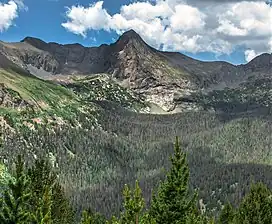 East aspect, from Music Pass | |
| Highest point | |
| Elevation | 13,610 ft (4,148 m)[1][2] |
| Prominence | 744 ft (227 m)[2] |
| Isolation | 1.70 mi (2.74 km)[2] |
| Coordinates | 37°55′28″N 105°32′25″W[3] |
| Geography | |
  Tijeras Peak | |
| Location | Great Sand Dunes National Park and Preserve, Saguache County, Colorado, United States[3] |
| Parent range | Sangre de Cristo Range[2] |
| Topo map | USGS 7.5' topographic map Crestone Peak, Colorado[3] |
Historical names
- Tijeras Peak – 1970 [3]
- Tiseras Peak
See also
- List of Colorado mountain ranges
- List of Colorado mountain summits
- List of Colorado fourteeners
- List of Colorado 4000 meter prominent summits
- List of the most prominent summits of Colorado
- List of Colorado county high points
References
- The elevation of Tijeras Peak includes an adjustment of +1.721 m (+5.65 ft) from NGVD 29 to NAVD 88.
- "Tijeras Peak, Colorado". Peakbagger.com. Retrieved November 6, 2014.
- "Tijeras Peak". Geographic Names Information System. United States Geological Survey, United States Department of the Interior. Retrieved November 6, 2014.
- Great Sand Dunes FAQ's #11
External links
| Book Cliffs |
| ||||||||||
|---|---|---|---|---|---|---|---|---|---|---|---|
| Elk Mountains |
| ||||||||||
| Elkhead Mountains |
| ||||||||||
| Flat Tops |
| ||||||||||
| Front Range | |||||||||||
| Gore Range |
| ||||||||||
| Grand Mesa |
| ||||||||||
| Laramie Mountains |
| ||||||||||
| Medicine Bow Mountains | |||||||||||
| Mosquito Range |
| ||||||||||
| Park Range | |||||||||||
| Rabbit Ears Range |
| ||||||||||
| Raton Mesa | |||||||||||
| San Juan Mountains |
| ||||||||||
| Sangre de Cristo Mountains |
| ||||||||||
| Sawatch Range |
| ||||||||||
| Spanish Peaks | |||||||||||
| Tenmile Range |
| ||||||||||
| Uinta Mountains |
| ||||||||||
| West Elk Mountains |
| ||||||||||
| Others |
| ||||||||||
| Federal | |||||||||||
|---|---|---|---|---|---|---|---|---|---|---|---|
| State |
| ||||||||||
| Trails |
| ||||||||||
This article is issued from Wikipedia. The text is licensed under Creative Commons - Attribution - Sharealike. Additional terms may apply for the media files.